A two-part series in defense of the traditional southern Sinai Peninsula site. In this first installment, we address the increasingly popular Saudi Arabia theory.
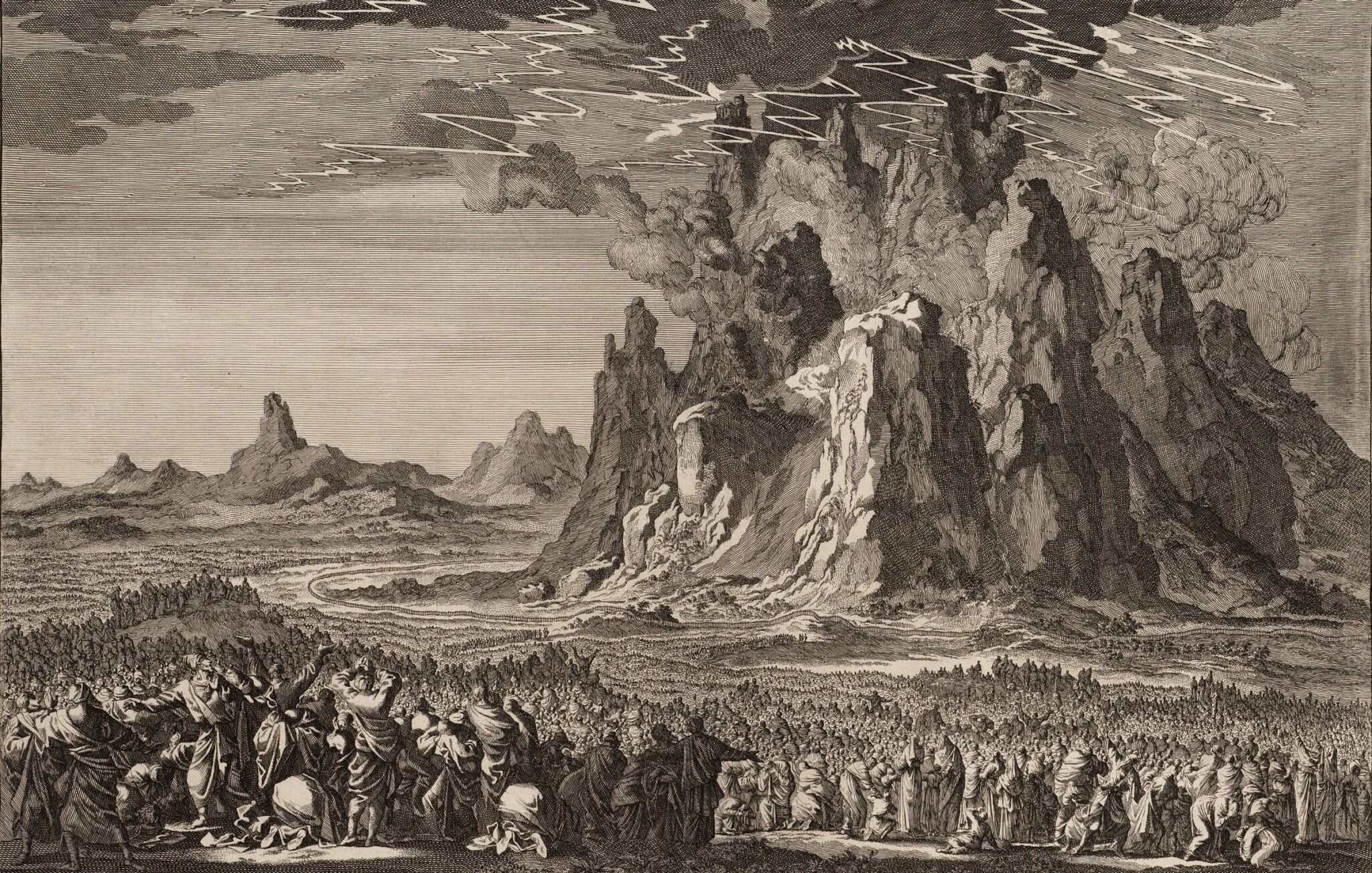
The Israelites at Mount Sinai (engraving by Jan and Kaspar Luiken, 1723)
Public Domain
Where is Mount Sinai, the biblical mountain of God?
Conventional wisdom has long held it to be in the southern Sinai Peninsula, identifying it with Jabal Musa (“Moses Mountain”). This traditional belief asserts that the Israelites, crossing the Red Sea at the northern end of the western Gulf of Suez, made their way down into this part of the peninsula and camped at the foot of the mountain from where they received the laws of God.
Yet over the past several decades numerous alternative theories have mushroomed. One in particular has risen from the fringes to prominence: the belief that Mount Sinai is not located in the Sinai Peninsula, but rather in northwestern Saudi Arabia—and that the Israelites crossed the eastern Gulf of Aqaba to get to it.
Adherents to the Saudi Arabia theory most commonly identify Mount Sinai with Jabal al-Lawz (“Almond Mountain”). Thanks to the efforts of enthusiasts and filmmakers over the last several decades, it has become such a popular theory that, in many areas, it has totally overshadowed the traditional Sinai location. (A YouTube search for “Mount Sinai,” for example, fronts many more hits relating to the al-Lawz/Saudi Arabia theory.)
More recently, these theories have been popularized by the Patterns of Evidence film series in The Red Sea Miracle (2020), The Red Sea Miracle II (2020), Journey to Mount Sinai (2022) and Journey to Mount Sinai II (2023).
Two years ago, after the release of the two-part The Red Sea Miracle and the number of questions among our readers that it raised, we published “Where Did the Red Sea Crossing Take Place?” Our article maintained the case for the traditional crossing site at the northern end of the Gulf of Suez, arguing an Aqaba crossing is biblically untenable—and that, if anything, “a stronger biblical case could be made for a Gulf of Suez crossing on the way to Jabal al-Lawz than an Aqaba-to-al-Lawz.”
But what about this question of Mount Sinai? Proponents of the Jabal al-Lawz theory bring to the table an immediately attractive visual spread: burned mountaintop, split rock and carvings of cattle-worship. But how watertight is their case? Is it enough to overthrow the traditional site of Mount Sinai in the southern Sinai Peninsula? And is the evidence behind the southern Sinai generally, and Jabal Musa specifically, really just artificially applied “tradition” without any historical or scriptural bones?
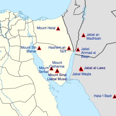
Presently, there are dozens of different proposed sites for Mount Sinai. For our purposes, we will focus on the two most prominent theories—Jabal al-Lawz in Saudi Arabia and Jabal Musa in the Sinai Peninsula. Despite the attractiveness of the Jabal al-Lawz/Saudi Arabia theory, it has fundamental flaws built into it—biblical inconsistencies, historical anachronisms, conflicting evidence and testimonies.
Having followed this debate, I appreciate that there are a lot of strong feelings, deeply entrenched personal theories and differing religious perspectives on this subject. It is my hope that this represents a fair, measured and reasonable approach that will be helpful and instructive to those on all sides of the aisle.
Let’s cut right to the chase: Underpinning this entire debate is the assumption that we can’t know where Mount Sinai was based on the modern name of the peninsula (“Sinai”)—that this was simply a name later applied to the area based on the traditional identification of Jabal Musa as Mount Sinai. The claim is that this territorial appellation can only be traced with any real certainty at least as far back as the early fourth century c.e. and the association of the site with the Empress Helena.
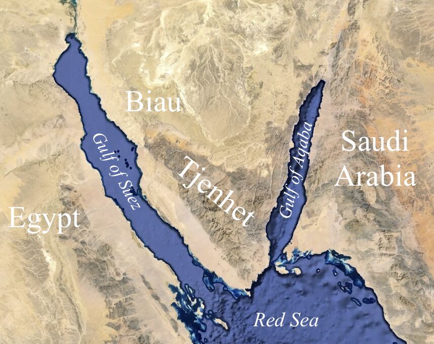
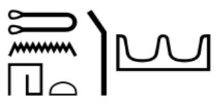
Yet this foundational premise, which has propped up Saudi Arabia theories for the last century and a half, may now be collapsing thanks to recent research. In February 2023, Egyptologist Dr. Julien Cooper published an article titled “The Earliest Mention of the Placename Sinai: The Journeys of Khety,” identifying an Egyptian use of this term for the southern part of the Sinai Peninsula as early as circa 2000 b.c.e. The “much-traveled” royal Egyptian official Khety traversed this fringe, mountainous peninsula area, referring to it as the “hill-countries of Tjenhet” adjacent the mining territory of “Biau.”
Biau is an Egyptian reference apparently to the western-central part of the Sinai Peninsula, rich in copper and turquoise deposits (to which Egypt had long sent mining expeditions). Yet “[u]nlike Biau, the place-name Tjenhet has no meaning in the Egyptian language …. As a foreign word, the name almost certainly stems from a locally spoken Semitic language. Semitic speakers are well-known in the Sinai desert,” wrote Dr. Cooper. “The first four [hieroglyphic] signs are consonants and the last two signs are non-phonetic classifiers that tell the reader that this place-name was a foreign land.”
He continued:
The name is transcribed as Ṯnht in Egyptological transliteration, regularized in standardized translations as “Tjenhet.” Egyptian ṯ represents a sound close to the “ch” in chip, usually transcribed as tj by Egyptologists. In trying to find a Semitic etymology for this place-name, one is presented with the problem that there is no such ch sound in Semitic languages of the Levant. However, analyses of hundreds of Semitic loanwords in Egyptian texts shows that Egyptians did use their ṯ sound to transcribe a Semitic sound, namely s, the sound represented by the Hebrew letter samekh (ס) [the same Hebrew letter beginning the word “Sinai”]. …
The reasons why Egyptians used their letter ṯ for Semitic s are complicated, but most linguists conclude that the sound of samekh probably had an original and older pronunciation of a sound like ts [t͡s] (like cats) that later shifted to s by the time of biblical Hebrew. For Egyptian ears, this “old samekh” sound was closest to their ṯ. So when Khety’s scribes and biographers transcribed Ṯnht they probably heard something like t͡snht. As time wore on and sounds shifted, such a name would be later pronounced as snht. The final consonant -t in this place-name is a suffix, a common element in Bronze Age place-names across Canaan and adjacent lands that is often dropped by the time of Biblical Hebrew. Taking all this into account, the “later” pronunciation of snh recalls the name “Sinai,” Hebrew Sînay סיני. …
Khety’s Ṯnht was a large and mountainous land, which one “traveled round” (deben) …. It was large enough to contain multiple khaset or “hill-countries,” echoing the biblical Hebrew expressions har Sînay “Mount Sinai” or midbar Sînay “wilderness of Sinai.” …
Ṯnht must refer to the southern parts of the Sinai Peninsula.
He provides additional detail in his article, concluding that “the phonetic and geographic similarities between Ṯnht and Sînay would be amazingly coincidental. If Khety’s Ṯnht is the early form of ‘Sinai,’ then this suggestion supports the orthodoxy … [of locating] ‘Mount Sinai’ in the southern parts of the Sinai Peninsula, be it Gebel Musa or any other nearby peak …. [W]ell before Moses trod its mountains, local people already called it something close to Sinai.”
Dr. Cooper’s identification from the outset confirms the identification of the Sinai Peninsula as justly named after all and the region within which we should find our Mount Sinai. Nonetheless, our conclusion does not rest on this alone.
Pillars for a Location in Saudi Arabia
There are several foundational pillars to the theory of Mount Sinai in Saudi Arabia:
The Galatians Pillar: The Apostle Paul in Galatians 4 mentions “mount Sinai in Arabia” (verse 25). Surely this can only mean that the mountain was located in Saudi Arabia rather than in the Egyptian Sinai Peninsula?
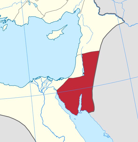
Yet during this Roman period, the Sinai Peninsula was indeed classified as Arabian territory, part of a geographic region referred to by the Romans as Arabia Petraea (see map, left). Thus, locating Mount Sinai within the Sinai Peninsula only fits with Paul’s statement. And this “Arabian” delineation of the Sinai has been the status quo throughout much of history (the modern “Egyptian” Sinai being more of an aberration). As summarized in William Smith’s 1854 Dictionary of Greek and Roman Geography, the Sinai was always the “[p]eninsula of the Arabs … one of the earliest seats of the Great Semitic race … a region which no other people has ever disputed with them” (emphasis added throughout).
The Sinai-Peninsula-Equals-Egypt Pillar: This similarly holds that the Sinai Peninsula anciently constituted part of “Egypt,” and therefore, in order for the Israelites to be free, they must have crossed over on the other side, via the Gulf of Aqaba, into what is now Saudi Arabia.
Yet on this, there is no question: The Sinai Peninsula was not considered part of ancient “Egypt.” Egypt did maintain a string of military fortresses in the northern Sinai, guarding the trade route into the Levant (fortresses that continued deep into Canaan). And Egypt also operated, quite sporadically, a number of mining outposts in the central Sinai. But they were just that: frontier outposts that had to be constantly guarded from marauding tribes during intermittent mining expeditions (which tended to take place during winter months).
Egyptologist Prof. James K. Hoffmeier summarizes it best in Ancient Israel in Sinai: The Evidence for the Authenticity of the Wilderness Tradition (page 37):
Sinai … was not considered by the pharaohs to be part of Egypt. Egypt proper, that is, kmt or the “Black Land,” was made up of the Nile Valley and the Delta, while the desert regions were called “the Red Land” (dšrt), which also meant “foreign land.” Areas outside of the Nile Valley and the Delta were also known as h3st, meaning “foreign land” or desert, written with the foreign land determinative [a determinative also in the name “Tjenhet”] …. One of the more important stelae from Serabit el-Khadim [central-western Sinai], dating to the sixth year of Amenemhet iii (ca. 1837 b.c.) … say[s] that he “came from Egypt” (iwt hr kmt) and refers to the area as h3st, foreign land. This inscription clearly shows that Sinai was considered a foreign land.
The Yam-Suph-Equals-Aqaba Pillar: 1 Kings 9:26 states that Solomon’s navy was docked at Eloth (Eilat) “on the shore of the Red Sea” (Hebrew, Yam Suph). This location is certainly on the northern end of the Gulf of Aqaba. As such, Saudi Arabia proponents argue that this must have been the body of water of the same name crossed by the Israelites, journeying into Saudi Arabia.
Yet as covered in the previous article, the name for the Red Sea—including its Hebrew equivalent—is used in modern terminology to refer to the entire body of water continuing south all the way to the Bab el-Mandeb Strait near the Horn of Africa. The gulfs of Suez and Aqaba are merely the northern tongues of the same sea. Why should this have been any different anciently—a name only applied to the Gulf of Aqaba?
Certain biblical passages also bear out the broader use of the term. Exodus 10:19 states that at the end of the plague of locusts the insects were carried away by a wind and cast into the Red Sea. Yet Egypt borders the Gulf of Suez and the main stretch of the Red Sea. Why would these insects have been blown hundreds of miles across these vast bodies of water in order to deposit them into the comparatively tiny Gulf of Aqaba? Clearly, the biblical term “Red Sea” (Yam Suph) did apply to the wider bodies of water.
1 Kings 9:26 actually constitutes key evidence against an Aqaba crossing. In the Greek Septuagint, the second-century b.c.e. Jewish translators rendered this gulf with a Greek name different to that used in every other reference to the sea crossed by the Israelites—implying that this gulf was not the body of water they crossed.
But there is one pillar for the Sinai-in-Saudi Arabia theory that rises above them all.
The Midian Pillar
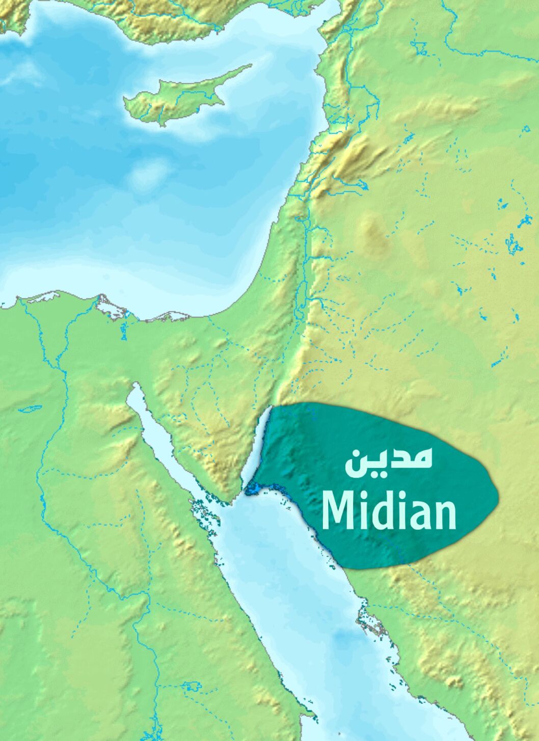
Later historians, such as Philo and Josephus (both first century c.e.) and Eusebius (fourth century c.e.), are sometimes appealed to in suggesting a Mount Sinai in Midian. This reasoning follows that Moses fled from Egypt to Midian, a region of northwestern Saudi Arabia; therefore, this must be the location of Mount Sinai.
Yet classical historians are necessarily consulted because the Bible nowhere states that Mount Sinai was in Midian; if anything, it states the opposite. And to a degree, the same is true of these classical historians.
One prominent proponent, an author and filmmaker, stated in a 2021 interview that Philo “specifically says that Mount Sinai is the tallest, and most holy or sacred mountain in the district of Midian” (read this passage in Philo’s On the Life of Moseshere, specifically 2.14.70). While Philo does state that Moses had “gone up into the loftiest and most sacred mountain in that district,” he does not mention “Midian.” In fact, there is not a single mention of “Midian” in his entire text.
Next, the interviewee quoted Josephus’s Antiquities of the Jews, which “says that ‘Now Moses, when he had obtained the favor of Jethro … he stayed there in Midian, and he fed his flock, but sometime afterward, taking his station at the mountain called Sinai, he drove his flocks there to feed them. This is the highest of all the mountains thereabout’” (read Josephus’s passage here, specifically 2.12.1). Yet again, the passage does not contain the words “in Midian.” Midian is not mentioned at all in this chapter of Josephus. It is mentioned twice in chapter 11 (once as a heading and once referring to the fleeing Moses arriving in “the city Midian”).
The fact that neither Philo’s nor Josephus’s quotes mention Mount Sinai “in Midian” makes the interviewee’s conclusion all the more curious: “So you have these two, nearly-identical statements: That Mount Sinai is in the region of Midian, and that it’s the tallest mountain in the region.” These statements are nearly identical—in that they don’t mention Mount Sinai “in Midian.”
Josephus never even mentions Midian or Midianites in the entirety of Book 3 of Antiquities—the book describing the Israelites at Mount Sinai. He does mention Midianites in Book 5 in the general context of the wilderness sojourn—specifically, “the posterity of Jethro, the Midianite”—but notes that these relatives of Moses “had left their own country, and followed them [the Israelites], and accompanied them in the wilderness.”
There is even a level of oddity to Eusebius’s fourth-century c.e.Onomasticon, sometimes quoted as locating this “mountain of God in the land of Madiam.” While some translations have “of Madiam” (as in the following publication), others read “mountain of God in the land ofMoab” (as in the following version). Yet without bogging down in this debate, we already have the widely recognized identification of Mount Sinai in the Sinai Peninsula in the fourth century c.e. anyway.
Later authors aside (whose works regularly contradict one another and often even the Bible itself), the Bible must serve as our baseline guide—and it never mentions Mount Sinai in Midian.
The Bible does describe Moses as having fled from Egypt into Midian (Exodus 2:15). This territory is broadly recognized as at least generally occupying the northwestern part of Saudi Arabia, primarily along the eastern side of the Gulf of Aqaba (see map, right). Still, it’s worth noting the ambiguity surrounding the exact extent of Midian (some cartographers have even designated much of the Sinai Peninsula territory as “Midian,” as in map A-4-2-22 in the following link).
Yet Exodus 3:1 describes Moses’s very distant journey to Mount Sinai: “Now Moses was keeping the flock of Jethro his father-in-law, the priest of Midian; and he led the flock to the farthest end of the wilderness, and came to the mountain of God.” The King James Version renders it “the backside of the desert.” This word for “backside” is also used anciently to refer to the west. Directionally, the ancient world was east-oriented (facing the most obvious directional sign in the sky: the rising sun). Related words for “left” (smol) and “right” (yemen) simultaneously referred to “north” and “south” (case in point Yemen, at the southernmost end of the Arabian peninsula). Thus this word relating to one’s “backside” refers to the west, befitting the Sinai Peninsula, west of land traditionally associated with Midian. As such, several translations, such as the Revised Standard Version, say Moses went to “the west side of the wilderness.”
Pointing to this same westward conclusion is the description of Moses meeting Aaron, in the context of his return journey into Egypt. In Exodus 4:18, Moses returns to his family in Midian, where he seeks his leave. In verse 20, he packs up his family and departs. Verses 24-26 describe an incident at an inn on the way to Egypt in which Moses’s family separates and evidently returns to Midian (compare with Exodus 18:2-3). Exodus 4:27 then describes Aaron being told by God to “[g]o into the wilderness to meet Moses,” where they reunite at the “mount of God”—a mountain therefore logically located generally west of Midian, and east of Egypt—within the Sinai Peninsula.
But would such a long journey into the Sinai Peninsula have been unlikely for the shepherding Moses? Bedouin throughout history have regularly migrated to this peninsula “in search of water and pasturage” (Encyclopedia Britannica, article “Sinai Peninsula”). Compared to neighboring regions, the southern, mountainous region of the Sinai is surprisingly rich in water and vegetation during certain times of the year. Bedouin have been observed ascending these particular mountains during the summer months with their flocks, as explained in Ancient Israel in Sinai (page 142). It’s not unusual for ancient shepherds to take their herds exceptionally long distances. Recall the example of Jacob’s shepherd-sons: Joseph found them pasturing their sheep around 100 kilometers (60 miles) away from where they were supposed to be—and in the already fertile region of northern Canaan (Genesis 37:14-17). In Professor Hoffmeier’s assessment, it “cannot be ruled out that Midianites, a pastoral-nomadic people, would have grazed their flocks in nearby Sinai” (ibid, page 121).
Exodus 18 is another key passage that rather clearly implies that Mount Sinai was located outside of Midian. This is the account of Jethro’s visiting family referenced by Josephus. Verse 27 states explicitly that Mount Sinai was located in another land entirely to that in which Jethro lived: “Moses let his father-in-law depart; and he went his way into his own land.” Many translations render this last word (ארץ) justly as “his own country” (as does Josephus)—logically inferring that Mount Sinai was not in his country of Midian but located in an entirely separate “country” outside of it.
Another logical question: If Mount Sinai really was “in Midian,” where are all the Midianites? Besides these journeying relatives of Moses, why are the Israelites—throughout their 40-year sojourn—never described as encountering them? Why do Midianites only appear just before the Israelites are about to enter Canaan, on the eastern side of the Jordan River? (Numbers 22, 25, 31). The Israelites instead encounter others in the vicinity of Sinai—namely, the Amalekites (Exodus 17). Where are all the Midianites—whose numbers, less than two centuries afterward, overwhelmed Israel? (Judges 6:6).
Finally, if Mount Sinai really was “in Midian,” why doesn’t the Bible—even the earliest classical historians—clearly say so in any of their many references? The Bible does not shy away from making such outright geographical references. Why is there no such direct reference?
The logical conclusion seems almost resounding: Mount Sinai was not in Midian. Far from any of these pillars supporting Mount Sinai in Saudi Arabia, they do just the opposite. They support locating Mount Sinai in “the farthest [western] end of the desert” of ancient Arabia: the Sinai Peninsula.
But what about Jabal al-Lawz, the split rock, the burnt mountaintop and depictions of cattle worship?
Certain geographical and archaeological features at and around Jabal al-Lawz have led to an increasingly popular embrace of this as the “true” site of Mount Sinai. Some of these features appear at first glance to be unequivocal—proof positive that this must be the region and features described in the Bible. We’ll examine them here, one by one.
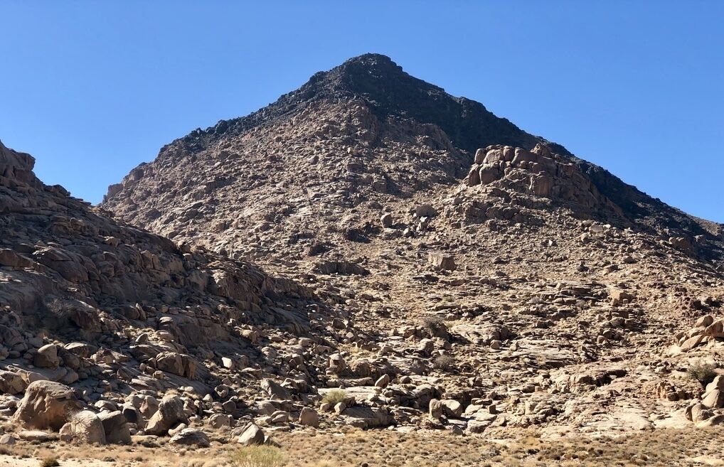
The ‘Burnt Mountain’: The classic image is one of a prominent burned-looking peak, towering over other, normal-looking mountains. This is often concluded to be the result of God’s presence on Mount Sinai, as described in Exodus 19—the place where God descended in “fire” to deliver the Ten Commandments (verse 18).
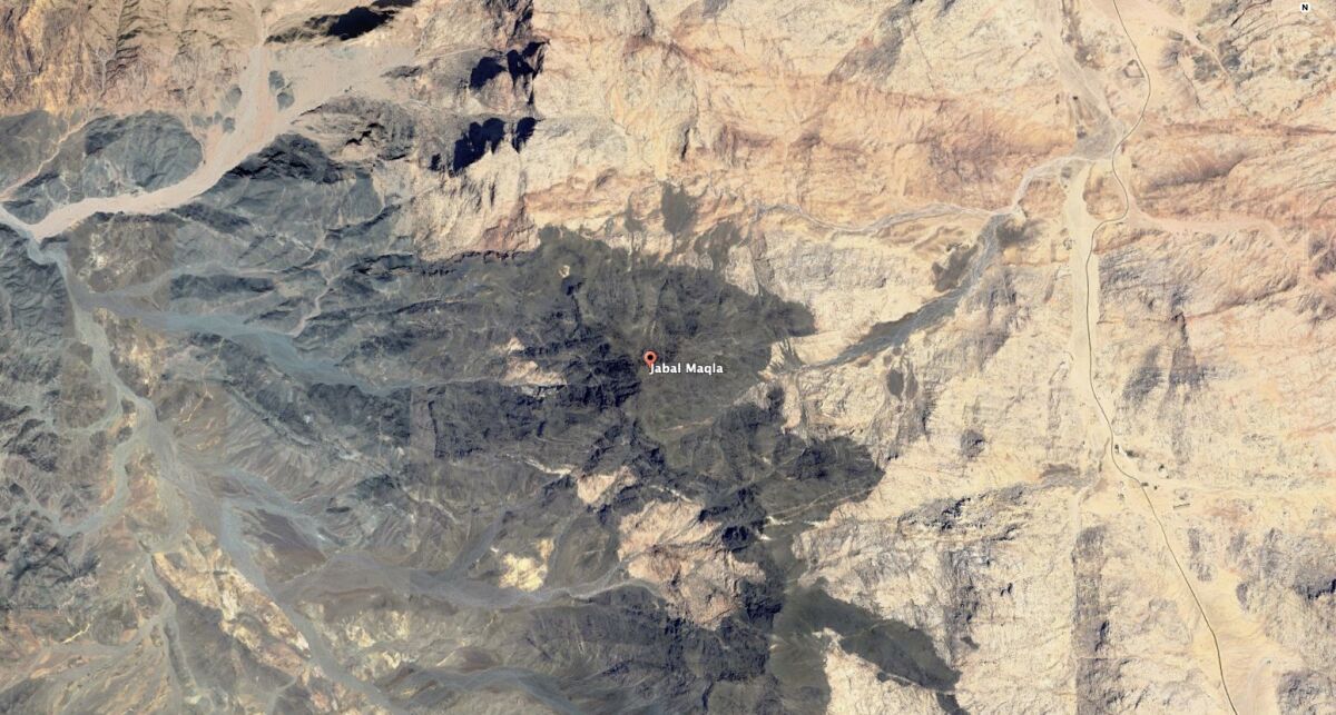
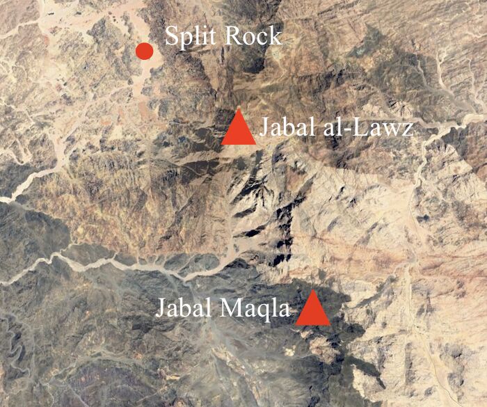
Actually, there is a great deal of misattribution applied to this mountain. This mountain is not Jabalal-Lawz; this mountain is Jabal Maqla (“Burnt Mountain”), located around 7 kilometers south of al-Lawz. This mountain has been misidentified as Jabal al-Lawz by a number of key early proponents, resulting in a string of so-called “calamitous errors” and “monumental blunders” in attribution. For example, a standard appeal by proponents to the classical authors—that the mount is the “highest of all the mountains thereabout” (e.g. Antiquities of the Jews 2.12.1)—would fall flat, given that Maqla is roughly 150 meters (500 feet) shorter than al-Lawz. Some proponents therefore argue that Maqla at least seems tallest standing in front of it. Others, given the twin biblical names “Horeb” and “Mount Sinai,” make a distinction between the two: Maqla as Horeb and al-Lawz as Mount Sinai. Yet this causes other issues, such as in relation to the location of the “split rock” (more on this further down).
Questions of attribution aside, what about this dramatic-looking, “burned” surface of Maqla? Is this evidence that this is the summit of Horeb, upon which the fiery presence of God came down?
The surface of Jabal Maqla is black because it is part of a Precambrian volcanic field made up of contact metamorphic rocks. And they are not found on this mountain alone—in fact, the entire mountainous region continuing for hundreds of square miles to the south is of this same blackened nature. Of course, the black peak of Jabal Maqla looks more impressive visually, since it happens to be a high peak at the very end of the field, standing out in greater contrast to the “normal” mountains and ridges in front of it. Yet in the words of geologist Dr. John Morris, “The Jabal Maqla rock I examined is normal metamorphic rock with nothing strange about it. Fire does not change the color of granite. We know for certain that the black rock at the summit of Mt. Maqla is natural and not the result of heat or fire.”
The Bible, for its part, never suggests the mountain as being blackened by God’s presence—just the opposite. The account of the “burning bush” on the mountain (Exodus 3) takes pains to describe that no trace of fire was left behind. “Moses said: ‘I will turn aside now, and see this great sight, why the bush is not burnt’” (verse 3)—not “maqla.” Did fire on the mountain selectively burn some things, but not others? Moses, following the Exodus, descended from the mountain with a face radiating light—but of course, none of his clothes were singed, nor is there any indication that the hewn stone tablets were blackened. Were some stones selectively burned and others not? The biblical theme here is consistent. (Whose presence is it anyway, theologically speaking, that “blackens”?)
Finally, the blackened surface on Jabal Maqla is such a prominent feature that it would surely have been described, if not in the biblical account, at least in the later classical accounts. Indeed, that is the key described feature of Jabal Maqla, why it is so-named as “Burnt Mountain.” Yet we have zero ancient testimony to a “blackened” Mount Sinai or Horeb.
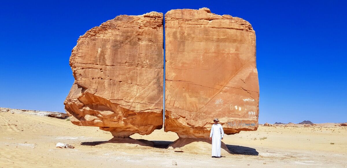
The ‘Split Rock’: A massive “split rock” within a northern valley of this region is also popularly portrayed as the one that the water miraculously came out of. It is a compelling-looking image. But here again we have several issues, causing several prominent al-Lawz proponents (such as geologist Dr. Glen Fritz) to dismiss this rock as having any connection to the one described in the Bible.
First, keep in mind that there are a number of examples of such naturally split monolithic rocks, particularly in this region of Saudi Arabia. This is apparently due to a phenomenon known as “frost wedging,” which causes such peculiar vertical splits in rocks (as explained in the following video), together with wind erosion. Also note that the Exodus accounts never explicitly state that this miracle rock split into two parts; the Torah passages simply describe water “coming out of” a rock. A different mechanism seems to be suggested. Psalm 78:16, for example, states that streams (nozlim, נוֹזְלִים) emerged out of the rock. The rock is repeatedly referenced in the singular, with streams or rivers—plural—emerging from it. (More on this water-from-rock miracle in Part Two, including a connection to a very peculiar rock near Jabal Musa.)
Yet the major issue with this rock formation, leading it to be abandoned by so many leading al-Lawz proponents, is that it is on the wrong side of the mountain range; given attempts at recreating a realistic sojourn route into Saudi Arabia from Aqaba, this side of the mountain range would have been inaccessible. Further, its location in relation to Horeb—if Horeb is to be identified with Jabal Maqla—appears to contradict several biblical passages: Exodus 17:6 calls it the “rock in Horeb,” and Deuteronomy 9:21 says that the brook “descended out of the mount.” Yet this split stone is located in a distant valley several kilometers northwest of al-Lawz and even further away from Jabal Maqla.
‘Calf Worship’: Another feature popularly highlighted on various websites and in videos is the rock art (petroglyphs) around Jabal Maqla/al-Lawz. This rock art shows various images, including cows surrounded by apparently naked individuals. Surely these are depictions of the “naked” Israelites worshiping the golden calf (Exodus 32).
Yet these are very typical petroglyphs, from entirely different periods, found all across the Middle East—from Egypt all the way down to the southern end of the Arabian Peninsula. There are hundreds of thousands of these images across these expanses. Further, these are not images of naked men and women dancing around a single calf; these are typically men, often portrayed with bows and arrows, and surrounded by ibexes, as well as cattle and other animals. Why? Many of these are hunting scenes. And the emphasized sexual nature of these stick-figures is very typical. It is notable that similar artwork—in some cases, with even more convincing motifs—has been used to make the case for a Mount Sinai at Har Karkom, along the border of the Sinai Peninsula and Israel. Note also the publication just last month of “over fifty newly discovered rock inscriptions of cows, ibexes, tally marks, and graffiti” at Wadi el-Hudi, near Aswan—deep in the south of Egypt.
‘Altar,’ Pillars and Pottery: Various architectural features have been proposed at the site of Maqla/al-Lawz, including walls of an “altar” and pillar bases. This area was in fact excavated and described in a 2002 volume, titled Al-Bid: History and Archaeology. The remains, put simply, are over a millennium too late. These are very typical Nabatean and Roman period remains. This area was the site of a flourishing Nabatean marble quarry, and the pillar fragments at the site are classic examples of pillar fragments of this period. And far from architectural features belonging to an altar, this is described in the excavation report as a Nabatean residential and animal husbandry area. (The massive V-shaped structure is entirely unlike anything remotely resembling the design of an altar, biblical or archaeological.)
These and other such points (not covered here) were all aptly summarized as false lines of evidence by al-Lawz and Aqaba crossing proponent Steve Rudd. Rudd was featured on Patterns of Evidence:The Red Sea Crossing for his own particular theory of the crossing site. Part of his talk, however, was cropped out—as he explains in a 2022 lecture (less-than-subtly titled “Bogus Unicorn Internet Archaeology of Mt. Sinai in Arabia at Mt. Lawz”):
A couple of years ago, when I was filming with Tim Mahoney, Patterns of Evidence and Red Sea Crossing II … Mahoney was asking me the question, and it went something like this … “Steve, we know that you do believe that Jabal al-Lawz is Mount Sinai. Tell us, as an archaeologist, what evidence is there that Moses was, archaeologically, at Jabal al-Lawz in Saudi Arabia?” And I replied, “Nothing, I’m not aware of any.” And then there was a pause, and then you hear somebody yell “Cut!” …
In the end, just like I said to Tim Mahoney, there is no known archaeology for Mount Sinai at any real site that I’m aware of.
He’s right. But is this as big of a problem as it is sometimes made out to be? It’s worth remembering that we are talking about the remains of tent-dwellers, lodged at this very specific location for less than a year, at a singular point in time nearly 3,500 years ago, in a scavenged desert trekked in the intervening periods of antiquity by untold numbers of people. As Prof. James Hoffmeier points out, traces “even of 19th-century Bedouin … are ‘difficult to identify’” (Ancient Israel in Sinai, page 150). He describes his 1999 excavation of Tell el-Borg in the northern Sinai: Returning to his site just eight months later, all trace of the workers’ campsite, even their fire pits, had disappeared entirely. This is simply the way of the desert—it swallows up everything.
With a paucity of any real archaeological evidence for any site, then—including at al-Lawz—what takes center stage is the biblical itinerary (Numbers 33:5-15). It is an itinerary that, as we will see in Part Two, cannot be forcibly molded to fit Aqaba and Saudi Arabia—but one which tidily fits a crossing at the Gulf of Suez and sojourn into the Sinai Peninsula. It is a journey from the Red Sea through multiple successive wildernesses and campsites—a journey leading the Israelites to the shores of the Red Sea again (verse 10)—a journey quite clearly from the Gulf of Suez southeast, parallel the waterway, down into the southern Sinai Peninsula.
In the next installment, we’ll trace the journey of the Israelites from the northern Gulf of Suez down to Jabal Musa.
Endnote: Helena’s Sinai vs. Wyatt’s Sinai (and Beke’s Arabia)
Some criticism is leveled by Saudi Arabia proponents against the traditional location of Jabal Musa as having simply been one of the many biblical sites artificially identified in the fourth century c.e. by the Empress Helena. We argue that this is not the case. Nevertheless, this charge is an interesting one, given that sites supposedly attributed to Helena pale in comparison to those associated with the originator of the Jabal al-Lawz theory, Ron Wyatt.
Wyatt (1933–1999), a Tennessee-based nurse anesthetist by profession, traveled to the Middle East multiple times over a two-decade period looking for biblically significant finds. Among his lengthy list of “discoveries” are the “real” Mount Sinai (Jabal al-Lawz), the “real” Red Sea crossing site (the Gulf of Aqaba, via Nuweiba Beach), Noah’s Ark (the geological formation at Durupınar), the Tower of Babel, Sodom and Gomorrah, sunken chariot wheels of pharaoh’s army, Goliath’s sword, the location of Jesus’s crucifixion, the “blood of Jesus” (which had “24 chromosomes”—“23 from Mary, and one from God”), and the ark of the covenant (which he claimed to have opened up, removing the Ten Commandments for filming purposes). Wyatt also described meeting angels assigned to guard the ark, as well as meeting with Jesus himself at the Garden Tomb. Unfortunately, this ark of the covenant “discovery” has been seen by no one else, the film of the ark encounter has been secreted in an undisclosed country (with a keeper who has “forgotten” the contents), and Jesus’s blood test results have never been produced (read more about this peculiar subject here).
Ron Wyatt first proposed the idea that Mt. Sinai was at Jebel al-Lawz. Whatever one may think of Ron Wyatt’s “discoveries,” he should be given full credit for this discovery. … [S]ome proponents of Jebel al-Lawz not [associated] with Ron Wyatt requested that I not mention him. … They feared that mentioning them in the same paragraph as Wyatt would result in “guilt by association”! I pointed out to them that, when publishing research results, one must begin with a discussion of the history of research and include a review of the literature on the subject. Ron Wyatt is the key player in this discovery. …
Ron Wyatt went to Jebel al-Lawz in Saudi Arabia with his two sons in 1984. They were arrested for entering Saudi Arabia illegally and were expelled after 78 days. Eleven months later, Wyatt returned with David Fasold and his “molecular frequency generator” to look for the “gold of the Exodus.” Again they were expelled and made to promise that they would not return to Saudi Arabia ….
Even the general theory for a Mount Sinai in Saudi Arabia has unusual origins. This is often traced back to the 19th-century traveler Charles Beke, who theorized that the biblical description of Mount Sinai matched that of a volcano, and thus sought to identify the site with the volcanic mountains of northwestern Saudi Arabia (as published in his book Mount Sinai a Volcano). Yet in accommodating this new, much further eastern theory, he theorized that the “Egypt” described in the Bible was not the infamous Egypt of antiquity but was instead a vanished kingdom in the eastern Sinai Peninsula itself!
Originally expecting to find Mount Sinai in the once-active volcanic area of “Harra Radjla,” Beke embarked on a journey to the region. He summarily found a mountain in Saudi Arabia he believed to be the one—Har-Nur (“Mount of Fire”)—yet this mountain did not appear to be volcanic. Nonetheless, embracing this new identification, Beke rescinded his earlier views, confessing that he had been “egregiously mistaken with respect to the volcanic character of Mount Sinai …. [T]he appearances mentioned in Scripture were as little volcanic as they were tempestuous” (Discoveries of Sinai in Arabia and of Midian, pages 561, 436).
In the words of Professor Hoffmeier: “Beginning his geographical study so far off the mark means that there is little likelihood that any of his following reconstruction can be taken seriously. Unbelievably, many of those who appeal to Beke’s work as an authority on the geography of the wilderness period conveniently ignore this” (Ancient Israel in Sinai, page 131).