Over the decades of archaeological research across Israel, piecemeal evidence of the 10th-century b.c.e. kingdom has been uncovered at various sites. There are the widely spread Solomonic cities of Gezer, Hazor and Megiddo, paralleling 1 Kings 9:15, with all sites featuring matching Iron Age gatehouses. There’s a Davidic-era site here, another there, like Khirbet Qeiyafa and Tel ‘Eton. And then there are the impressive remains of 10th-century construction in Jerusalem.
Until recently, these sites were generally studied individually. Archaeologists had not seriously investigated whether these individual sites, or at least some of them, might be part of a broader network of urban centers.
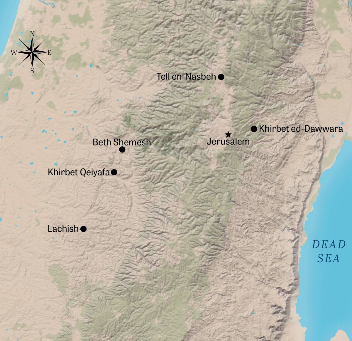
Prof. Yosef Garfinkel from Hebrew University has been examining the question of the formation of David’s kingdom more methodologically, from a geographical perspective. In May 2023, he published what may prove to be a watershed article in Hebrew University’s Jerusalem Journal of Archaeology (jjar) titled “Early City Planning in the Kingdom of Judah: Khirbet Qeiyafa, Beth Shemesh 4, Tell en-Nasbeh, Khirbet ed-Dawwara, and Lachish V.”
His publication presented a brand-new reexamination of cities geographically proximate to one another and bearing similar design and construction parallels, with similar 10th-century dating. His article presented evidence not of a random smattering of independent Davidic-period structures, but rather, of a carefully planned and geographically linked network of cities forming the very core of the united kingdom of Israel—particularly during the reign of King David and, later, kings Solomon and Rehoboam.
“These sites have far-reaching implications for understanding the urbanization process, urban planning, and borders of the earliest phase of the kingdom of Judah,” wrote Garfinkel.
Case Made by Casemates
During excavations at Khirbet Qeiyafa from 2007 to 2013, Professor Garfinkel was stunned to find evidence of a single-period Judahite site that was in operation for only 20 to 30 years. The site was radiocarbon-dated squarely to the end of the 11th and start of the 10th century b.c.e., the time of King David (see our article Khirbet Qeiyafa for more information).
Khirbet Qeiyafa is situated in the strategic Shephelah (Judean lowlands) region and is a “day’s journey” southwest of Jerusalem (30 kilometers, or 20 miles). This distance was confirmed by Professor Garfinkel and Ganor when they (in true experimental archaeological fashion) made the trek on foot themselves.
Given the exceptionally tight window of dating, various unique aspects of Khirbet Qeiyafa can be used as a diagnostic parallel in comparison to surrounding locations. Armed with the findings from Khirbet Qeiyafa, Professor Garfinkel compared its closely confined, cleanly defined stratum with a handful of other, more loosely anchored regional sites that have been excavated over the past century. He reexamined finds from Beth Shemesh, Tell en-Nasbeh and Khirbet ed-Dawwara and summarized the results of his research in the above-mentioned jjar article.
The most notable parallel between these cities was the presence at all sites of a unique, Judean-style casemate wall system, which is particularly endemic to the southern Levant (Israel). A casemate wall is a fortification line made up of essentially two parallel walls—a “double wall”—separated by a space in between. These parallel walls are each typically of a much narrower width than that of a solid fortification wall. In peacetime, the open corridors between these parallel walls can be used for storage or even as residences. In war, however, these open spaces can be filled with rubble, essentially transforming the two weaker, parallel walls into one massive, solid-style construction. (Casemates are alluded to in several biblical passages, including Joshua 2:15 and Isaiah 22:9-10.)
Still, examples of casemate walls can be found in Israel spanning the Middle-Late Bronze and Iron Ages. As highlighted by Professor Garfinkel, however, the nature of the casemate wall at Khirbet Qeiyafa—and at these other, related sites—is much more particular.
These city walls consist of a casemate, but more specifically with a notably Judahite-style peripheral belt of residential buildings attached to and incorporating this fortification wall. In addition, these wall-and-residential structures are then followed by an inner, peripheral street circuit. Examples of such specific city plans can be seen at Khirbet Qeiyafa, Beth Shemesh Level 4, Tel en-Nasbeh and Khirbet ed-Dawwara. (Lachish Level v is another case—more on this further down.)
Material Culture and Dating
Utilizing the tightly dated, single-use material and material culture from Khirbet Qeiyafa, Professor Garfinkel was able to identify other parallels between the sites—most notably, in the pottery assemblage, with parallel forms and key diagnostic sherds, such as those belonging to black juglets, Ashdod ware, red-slipped and hand-burnished pottery, and Cypriot black-on-white ware. Other parallels in material culture included similar faunal assemblages, notably with the exclusion of pig remains. Additionally, various examples of parallel proto-alphabetic script have been found at certain of the sites.
Beth Shemesh was one of the most remarkable sites highlighted by Garfinkel. This city is also a day’s walk from Jerusalem. This major biblical site had not previously been clearly linked specifically to the 10th century b.c.e., at least as a fortified settlement. Major excavations in the 1910s, ’20s and ’30s were less scrupulous but had at least recognized an Iron Age ii city surrounded by a casemate wall. In the 1970s, utilizing excavation maps from earlier excavations, Prof. Yigal Shiloh was able to interpret at least part of an Iron Age city with a casemate wall, rounded by an interconnected belt of houses within and a peripheral road. Excavations at the site from the 1990s until recently, conducted by Prof. Shlomo Bunimovitz and Dr. Zohar Lederman, successfully provided a sequence of strata for different periods (Levels 1-8).
While they identified Level 4 as an Iron i Canaanite village, they stated that “the Level 4 assemblage gives the impression of a pottery horizon belonging to the very end of the Iron i–beginning of Iron ii [circa 1050–950 b.c.e.]” (Tel Beth-Shemesh: A Border Community in Judah, Renewed Excavations 1990–2000: The Iron Age).
Professor Garfinkel notes that their excavations “overlooked the casemate city wall addressed by Grant, Avigad, Albright, Wright and Shiloh,” noting in addition that barely 100 square meters of Beth Shemesh Level 4 was uncovered—compared to 5,000 square meters of Khirbet Qeiyafa—and despite this, the Beth Shemesh 4 assemblage is “almost identical to the early Iron Age iia Judahite Khirbet Qeiyafa assemblage.”
He also highlights radiometric dating, particularly in regard to Level 4. “Why did Bunimovitz and Lederman fail to recognize the urban character of Level 4? Most likely, this is because they did not excavate the Level 4 casemate wall,” he writes. As such, Professor Garfinkel identifies Level 4 not as a late Canaanite site but rather as a powerful, fortified, urbanized Davidic-Solomonic site directly paralleling the other exemplar locations highlighted in his academic paper.
Garfinkel’s proposition is tantalizing for future excavation at this most significant site (one that is, unfortunately, heavily embroiled in controversy due to the major highway and surrounding constructions that cut right through the middle of it).

The two other sites highlighted by Professor Garfinkel in relation to the core kingdom of David and Solomon are Tell en-Nasbeh and Khirbet ed-Dawwara. Both sites are half a day’s walk from Jerusalem, due north and northeast of the capital city, respectively. Both sites likewise feature parallel pottery, stratigraphy and site layout.
Of Tell en-Nasbeh, Garfinkel suggests that despite the lack of radiocarbon dating from the site, the evidence indicates that the “earlier city with its casemate city wall was built during the early 10th century b.c.e.,” citing Dr. Omer Sergi’s 2017 article, “The Emergence of Judah as a Political Entity Between Jerusalem and Benjamin.”
Khirbet ed-Dawwara was excavated by Prof. Israel Finkelstein in the 1980s. At the time, the small (0.5 hectare) desert site was associated by the excavator with Iron Age i (just preceding the Israelite monarchy). However, Garfinkel notes that since the excavation of Khirbet Qeiyafa, it is clear that the pottery assemblage is comparable, and alongside the site plan of a casemate fortification with Judahite-style four-room houses, “the site might be more suitably dated to the early 10th century b.c.e. and the Iron Age iia.”
The final city highlighted by Yosef Garfinkel is Lachish. This city is slightly different from the other sites (it dates slightly later) and makes a good comparison with the ensuing urbanization of the kingdom. Professor Garfinkel has led several excavations within this prime site, located two days’ journey southwest of Jerusalem (with Khirbet Qeiyafa located directly in between). Within Level v of the site, Garfinkel’s team has uncovered (and continues to uncover) part of a fortified city exhibiting radiocarbon dates from the late 10th century b.c.e.
Like the other slightly earlier sites, Lachish exhibits a similar belt of peripheral structures abutting the city wall. However, the previously unidentified, 3-meter-wide wall itself is of a solid, rather than casemate, construction. Given these dates and slight divergences in style, excavators Garfinkel and Hoo-Goo Kang identify Lachish Level v as the city attributed to Solomon’s son Rehoboam, last ruler of the united monarchy (2 Chronicles 11:5, 9).
It’s in the Geography
Professor Garfinkel identifies these four cities in particular as the key that unlocks the “plan” of the early Iron iia kingdom of David and Solomon. In particular, he notes the deliberate geographical positioning of each city: “[N]one [is] more than a day’s walk from Jerusalem and, thus, may be considered as marking the kingdom’s geographical core.”
Each city was selected for its strategic situation. “They were calculably positioned to guard strategic roads leading into the kingdom,” Garfinkel writes. “Khirbet Qeiyafa controlled the Elah Valley, Beth Shemesh controlled the Soreq Valley, and Tell en-Nasbeh controlled the northern road to Jerusalem.” Khirbet ed-Dawwara, a smaller site in an arid climate, sat atop a strategic location overlooking the Transjordanian plateau and Judean desert.
Professor Garfinkel’s research provides important insight into the question of when Judah’s lowlands began to be developed. As he notes, “[S]ome scholars have argued that the kingdom of Judah’s expansion into the Shephelah occurred in the mid- or late ninth century b.c.e. …. However, Khirbet Qeiyafa iv and Beth Shemesh 4 show that this process was already on its way in the early 10th century b.c.e. at sites located one day’s walk from Jerusalem.”
That’s not all. Logically, with major sites located a full day’s walk one from another, smaller satellite sites will appear halfway, or a “half-day’s walk.” This is highlighted in more detail by Garfinkel, Igor Kreimerman and Peter Zilberg in their 2016 book Debating Khirbet Qeiyafa: A Fortified City in Judah From the Time of King David.
Garfinkel and his colleagues identified two particular sites, each a half day’s walk north of Jerusalem. The first is the aforementioned Khirbet ed-Dawwara. The second is Gibeon, a city identified as having been destroyed in the late 10th century b.c.e. by Pharaoh Sheshonq i (biblical Shishak) during his invasion of the Levant, and thus is another city on the scene during this early-to-middle, united monarchy time period. Tell en-Nasbeh can also now be added to this list.
Other sites are intriguing and await investigation. “Half a day’s walk from both Khirbet Qeiyafa and Hebron [Tell Rumeidah, David’s capital prior to Jerusalem, and a site of only limited, not properly published excavation] is Khirbet Kila, identified with biblical Keilah,” Garfinkel and his colleagues wrote. “It should be excavated to obtain information about the nature and size of the settlement during the 10th century b.c.e. … Now, since we have the Khirbet Qeiyafa assemblage and the pottery typical of the 10th century b.c.e. in Judah is known, it will be possible to identify these sites” (ibid).
Other Davidic sites highlighted, at least briefly, both in this 2016 book and in Garfinkel’s latest paper, include Tel ‘Eton, Tel Sheva viii, Arad xii and Khirbet al-Ra’i vii. Garfinkel, Kreimerman and Zilberg categorize these early kingdom sites into three types of settlement: 1) royal centers, 2) regional centers and 3) villages and farmsteads.
The royal centers within the core Davidic territory of Judah have been identified as Jerusalem, Hebron and Khirbet Qeiyafa (biblical Shaaraim). When this city fell out of use, it was replaced by Beth Shemesh. This site was later replaced by the Rehoboam-era sites of Lachish, Tel Zayit and Khirbet Shuwayka (Socho). These compare with parallel-sized cities (and even structural parallels, such as casemate walls) to the northern Israelite royal city sites such as Gezer and Hazor.
Examples of the regional centers highlighted by Garfinkel, Kreimerman and Zilberg are Khirbet ed-Dawwara, Gibeon, Keilah and possibly Kirjath-jearim.
Finally, there are the comparatively minor (in terms of archaeology) villages and farmsteads that would have been scattered in and around these centers. Naturally, most of these are unnamed and furnish only piecemeal archaeological remains. However, each provides evidence of the most important part of a kingdom—the general populace and productive citizenry. (See Chapter 14 of their book for more information.) One example of such is a 10th-century b.c.e. farmstead at the northern site of Horvat Assad. In 2022, excavators announced the discovery of a “substantial 10th-century b.c.e. Iron Age agricultural settlement.” This region makes up part of the wider territory allotted to the biblical tribe of Naphtali, as well as to the tribes of Zebulun and Issachar. The Bible describes this as an important agricultural area, particularly during the 10th century. 1 Chronicles 12:41 specifically names these three tribes as supplying agricultural produce to King David “in abundance.”
Tip of the Iceberg
In Prof. Yosef Garfinkel’s paper, only four Judahite cities were highlighted as providing convincing, clear representations of a carefully mapped, datable and comparable system of cities belonging to the Davidic-era kingdom. It is important to note, these cities do not constitute the sum total. In fact, they represent only a fraction of the cities of the kingdom of David and Solomon—or more specifically, a fraction of the core of the kingdom of David and Solomon.
For now, they represent some of the leading primary pieces of evidence attesting to the centralized administration and urban planning and development of the 10th-century b.c.e. kingdom.
