Fossilized Fish on Mount Everest—Proof of the Flood?
“And the ark went upon the face of the waters. And the waters prevailed exceedingly upon the earth; and all the high mountains that were under the whole heaven were covered” (Genesis 7:18-19).
Crazy, says the critic. In an article entitled “How Much Water Would Be Needed for Noah’s Flood,” one naysayer crunched the numbers required to cover Earth’s highest mountain, Everest. “[F]or the biblical Flood to have happened, the water on Earth had to miraculously multiply by about 250 percent,” he wrote.
That means, there needed to be more water than could be contained by 10 Atlantic Oceans to rain as much as the Bible claims. This raises one final point, where did all that water go?
I’m beginning to doubt the veracity of the Bible.
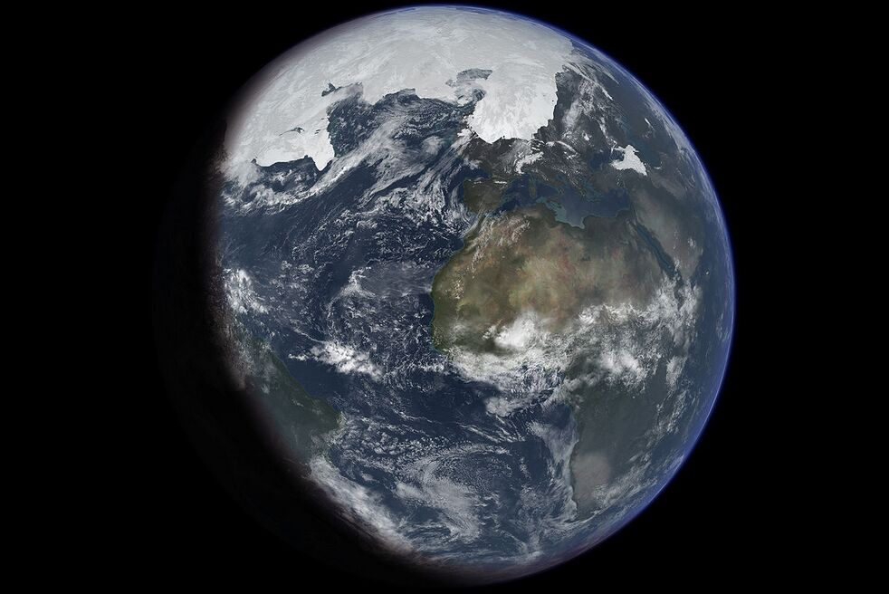
Putting aside the fact that the Bible states the water was not simply “rained” down (verse 11): Did you know that fossilized fish remains have been discovered on Mount Everest? That’s right—even the most die-hard, anti-Bible evolutionists accept that the territory of Mount Everest, at some point in Earth’s history, was covered with water. In fact, the general planet, at some point (or even several points) in its history, has been a watery abyss.
If you were to entirely smooth everything on Earth, leveling mountains and filling in valleys and sea trenches, the sea would not only cover everything, but the dry land would be submerged some 2.5 kilometers deep (over 1.5 miles). So yes, there is enough water on Earth to cover the existing landmass—let alone by the 7 meters the Bible says that Noah’s Flood prevailed above the highest peak (verse 20).
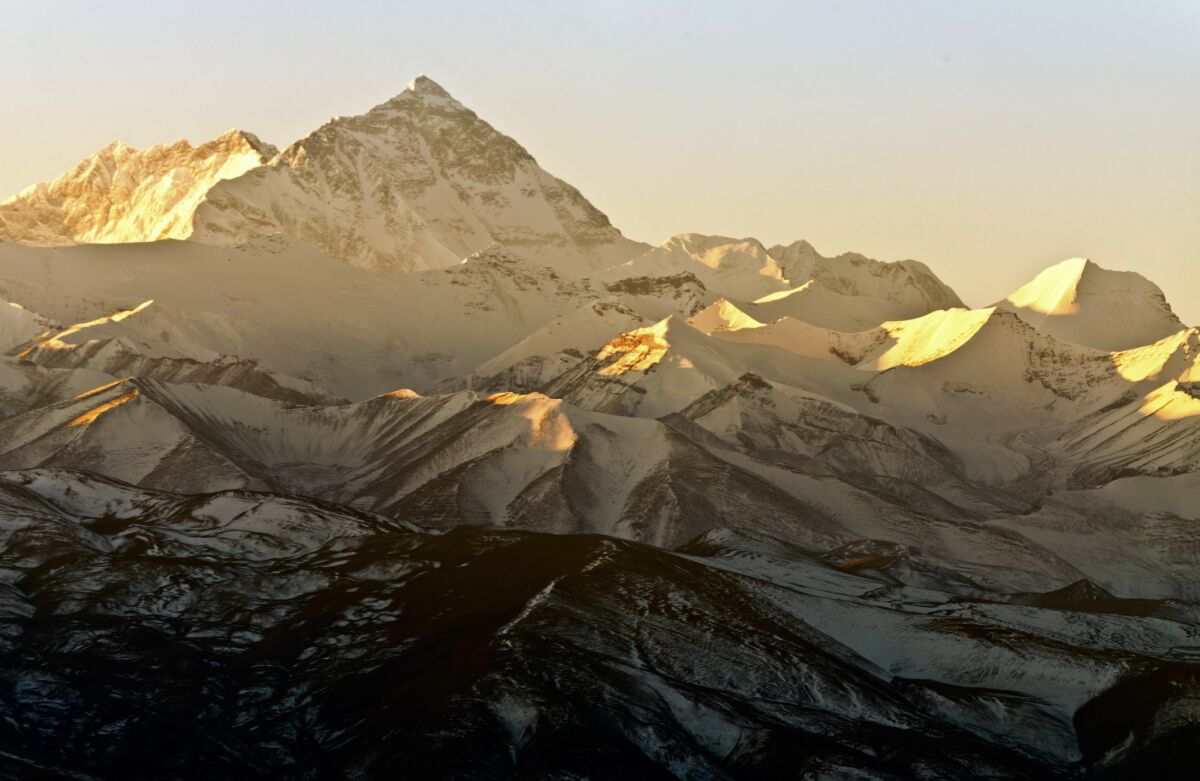
The question, then, must be asked: What are ancient fish doing atop Mount Everest? Is this evidence of the Flood?
Maybe; evidence of the physics, certainly.
Welcome to plate tectonics.
According to ‘the Science’
The presence of fossilized fish and coral atop the mountain—in fact, all over the Himalayas—naturally brings to mind the great Flood. How else could ancient fish have been fossilized up there?
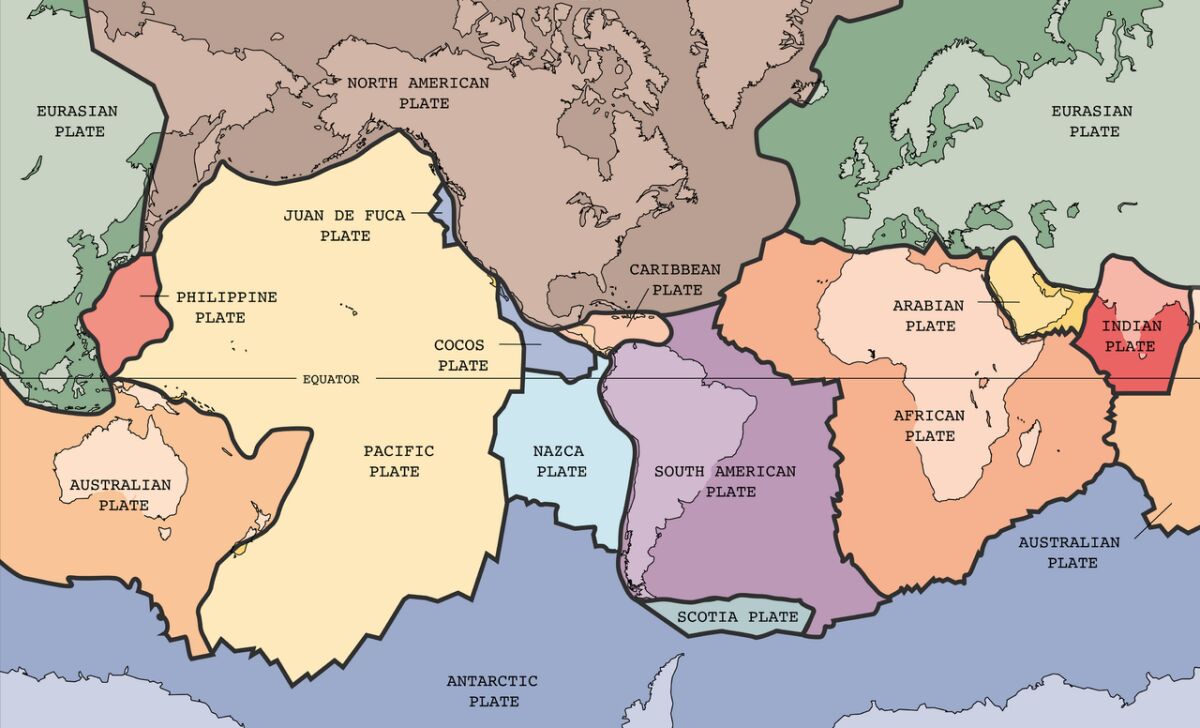
The Earth is made up of tectonic plates which, depending on how they gradually separate or collide with one another, form ocean trenches or mountain ranges. (It’s why my homeland of New Zealand, on the Pacific Rim, is gradually twisting and sinking—the “continent” of Zealandia is actually 94 percent underwater.)
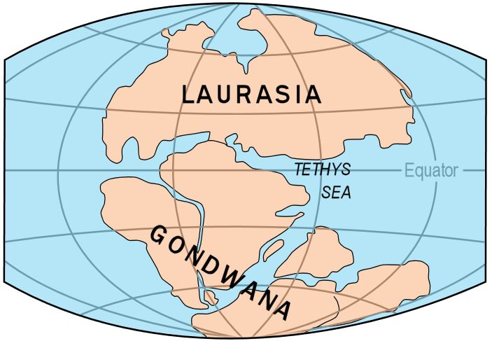
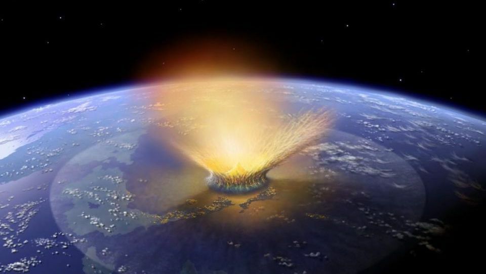
As such, the general scientific explanation for “fish in the Himalayas” is as follows: The territory of India was once part of a supercontinent called Gondwana. Around 150 million years ago, it broke off and “traveled” north toward Laurasia. At that time, the huge Tethys Sea, flourishing with marine life, separated the continents. After journeying about 100 million years, the landforms collided with extreme force and intensity, forming the Himalayan mountain range—and thus, driving up the “mountain seabeds” seen in the Himalayas.
Of course, there are a lot of “theoreticals” to this event—for example, its date has shifted quite dramatically: It was originally given an age 20 times greater than that established by later research (an especially significant discrepancy, when dealing in millions of years). Still, scientists today have a fairly good understanding of plate movements and the separation of modern continents from originally combined “supercontinents.” But that has not always been the case.
Over the past several centuries, select scientists have speculated on the matter of “continental drift”—based on how similar opposing continents appeared to one another. But even well into the 20th century, this concept was widely rejected, even ridiculed by mainstream scientists. It wasn’t really until around 50 years ago, with the work of geophysicist Jack Oliver in 1968, that continental drift became conventional science.
Continental drift, of course, is in this case used to explain the seabed-esque nature of the Himalayas. But really, rather than dismissing the biblical account, the mechanics serve only to support it. (And perhaps it is no surprise that the earliest proponents of the theory believed continental drift was caused by powerful “flood” action.)
Continental drift demonstrates not only how catastrophic landmass flooding can happen, with precisely the same amount of water and precipitation; it demonstrates that it did happen (such as evidenced by fossil remains on the highest mountains). And the Bible even alludes to such physics as God’s “tool,” relating to flooding.
‘Fountains of the Deep’
Contrary to the quote in the introduction, 10 Atlantic Oceans were not required to have “rained” down: Besides the 40-day torrential downpour the Bible describes, “all the fountains of the great deep [were] broken up”(Genesis 7:11). Or as the Christian Standard Bible translates it: “all the sources of the vast watery depths burst open.”
Psalm 104:6-8 provide more information (New Living Translation):
You clothed the earth with floods of water, water that covered even the mountains. At your command, the water fled; at the sound of your thunder, it hurried away. Mountains rose and valleys sank to the levels you decreed.
As already stated, there is far more than enough water on Earth to suffice for the biblical Flood. All that would be required is just what is discussed in Psalm 104: a shuffling of tectonic plates, a closing up of ocean trenches, a lowering of landmasses—or the reverse, as described, in order to lower the water level.
And plate movement is a lot more dramatic than you may think. It’s certainly not just a slow-forming gorge here, a mountain range there. Himalayas aside: What is the deepest seabed on Earth? Challenger Deep, within Mariana’s Trench—11 kilometers (7 miles) below sea level, you might say—the deepest-known point under water. But that’s barely thimble depth compared to the lowest-discovered seabed. Just last year, the “deepest” ever seabed was found, subducting into Earth’s mantle beneath the China landmass, somewhere between 400–700 kilometers (250–400 miles) underground. Now there’s some dramatic plate movement.
And as for Mount Everest, it’s still growing! Scientists believe it is increasing in height at a current rate of roughly 1 meter (3 feet) every 200 years. Let’s say that such a growth rate were precisely constant for millennia on end (something which does not happen in nature): Mount Everest would have been at least a dozen meters shorter with the biblical chronology for Noah’s day. That may not sound like much, but on a globe-girdling level, subtracting 12 meters depth of water—at 1 ton for every cubic meter—that’s oceans-worth.
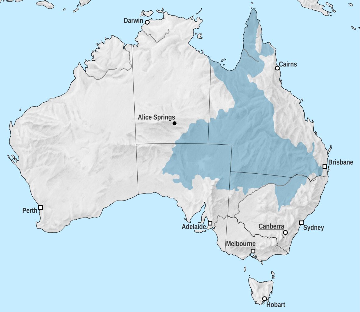
Added to dramatic plate action, there are any number of other sources for the great deluge. What about the untold numbers of massive underground aquifers? Australia’s Great Artesian Basin is one example: This freshwater basin stretches more than 1.7 million square kilometers (700,000 square miles)—“covering” roughly 22 percent of Australia’s territorial area—underground. It is the largest and deepest basin in the world (as far as we know)—up to 3 kilometers deep (nearly 2 miles), and believed to contain some 65,000 km3 of groundwater (15,600 miles3). Put another way, that’s 65 trillion tons of water. A great flood, caused by “all the fountains of the deep broken up”? I should think so.
And what about all the ice on Earth? Below is a video of what the Earth would look like if “all the ice melted.” Note that this is only current land ice alone, as it stands on Earth today—an incredibly paltry amount compared to that of prehistory, and not including additional effects of tectonic action, underground aquifers, etc. The resulting sea level? Approximately 70 meters (230 feet) higher.
https://www.youtube.com/watch?v=VbiRNT_gWUQ
Ice action is also mentioned in the Bible alongside God’s “tools” for correcting mankind. Job 37:9-13:
Out of the Chamber cometh the storm; And cold out of the north. By the breath of God ice is given, And the breadth of the waters is straitened. … And they are turned round about by His guidance, That they may do whatsoever He commandeth them Upon the face of the habitable world: Whether it be for correction, or for His Earth, Or for mercy, that He cause it to come.
https://www.youtube.com/watch?v=qRYDYKB2yRg
What about the supercontinent-size glaciers of the Ice Age, that buried entire prehistoric civilizations? Striking are the perfectly preserved, frozen Ice Age animal corpses that are found. And there is more to glacial action than just “ice melting.” The staggering weight of ice during the Last Glacial Maximum (dated roughly 20,000 years ago) actually compressed the land masses under them much lower. And because so much of the Earth’s water was locked away in these glacial ice sheets, the Earth and atmosphere were quite dry and drought-like. The sea level was so low back then, that scientists believe continental shelves were exposed.
Forget the few millimeters of sea level change we wring our hands over today: Scientists estimate that around 20,000 years ago, the sea level was 125 meters (410 feet) lower. Again, assuming no tectonic or basin action (something somewhat unreasonable, considering the staggering amount of shifting weight)—one might call the increase since then quite a “flood.”
Finally, according to the biblical account, the Flood carried on for a significant span of time—150 days (Genesis 7:24). And the Bible indicates that the waters did not totally recede to “normal” for years, if not decades afterward (i.e. Genesis 8). This was no immediate dumping-and-evaporating of “10 Atlantic Oceans.”
Still, in this modern age, the idea of a worldwide Flood is galling to many, seen as theological nonsense. But perhaps lesser known is that the idea of a world entirely covered in water is also a common part of the evolutionary theory of Earth’s history (for example, the Cryogenian Period—“Snowball Earth”—as well as new research published last year revealing early Earth was a continent-less “water world”).
But the idea of a Great Flood in more recent history is held in general disbelief. In answer to this, there are the ever present, fatal presuppositions behind traditional dating methods. But there is a burgeoning amount of evidence for recent catastrophic worldwide flooding that would fit well with the Noahide event, dated conventionally around or within 10,000 years ago, at the end of the Ice Age and a period known as the Quaternary Extinction Event—something that saw the mass extinction of “Ice Age animals,” as well as all other human life (Neanderthal, Denisovan, etc.), save for the Homo Sapiens.
Of Tidal Waves and Disappearing Landmasses
Here’s an example: The “Storegga Slide” is a dramatic event typically dated somewhere around 8,000-plus years ago—a chunk of seabed the size of Scotland shifted and caused dramatic tidal action, in conjunction with rising sea levels. It is the event responsible for separating Britain from mainland Europe (once connected by a land bridge, depicted below), completely submerging the huge territory known as Doggerland. This was no short land bridge from England to France: Doggerland connected Scotland with Denmark (and almost Norway). All gone, thanks to suddenly shifting seabed action, generating “waves of biblical proportions” that wiped out human populations (as reported here, based on new research emerging last summer).
And last December, new research in Israel revealed that inside of 10,000 years ago, the Holy Land was hit by a massive tidal wave—a mega-tsunami approximately 40 meters (130 feet) high. Researchers were able to estimate this by drilling sediment cores, noting depth and spread of this seaborne layer inland. By comparison, the 2004 Indian Ocean tsunami—the “most devastating in recorded history,” caused by an undersea earthquake and resulting in a death toll of some 230,000—reached a maximum of “only” 30 meters in height. The ancient Israel wave evidently leveled all Neolithic villages in the vicinity. As Genesis 7:18 (csb) reads:
The water surged and increased greatly on the earth ….
https://twitter.com/60Mins/status/1342590945485840386
As you read this article, underwater archaeologists are excavating submerged “Ice Age” sites along Israel’s coast—sites that disappeared under water at the end of the Ice Age, caused by the melting of ancient glaciers and rising sea levels. (Did you know that there is a huge monolithic structure at the bottom of the Sea of Galilee? It is one of the largest “cairns” ever discovered, estimated to weigh 60,000 tons.)
These are just a handful of examples of which new research has emerged over the past several months, from this related era. Other examples could be given, such as the house found buried nearly 100 meters beneath the Black Sea, and an ancient coastline up to 170 meters beneath the same body of water, by the famous underwater archaeologist Robert Ballard—features that were dated as sitting above-water within the last 10,000 years.
And is it just coincidence that virtually every culture around the globe has some form of “great Flood and ark” story, closely paralleling that of the Bible? It’s essentially a “cultural universal.” Coincidence? Or does it reveal some great global event that really did happen?
Two Great Biblical Floods
Back to our initial question: Are fossilized fish on Everest evidence of Noah’s Flood? Maybe; evidence of the physics, certainly. But they may also be directly related to another, earlier biblical flood entirely.
Did you know that the Bible actually describes two great floods?
This second (or rather, first) “flood” is described in Genesis 1. This chapter is well known as the creation chapter. Really, though, it would be better known as the re-creation chapter. That’s because the chapter describes two “creation” periods: The initial creation of Earth and the universe (verse 1); the cataclysmic destruction of that world (verse 2); and from verse 3 onward, the re-creation of the surface of the Earth.
Verse 2, in the Hebrew, describes the Earth becoming “tohu and bohu”—waste and decayed. This was not how God originally created it: Isaiah 45:18 says that God “created [the Earth] not a waste [tohu—the same word].” Psalm 104:30 backs this up, stating that following this period of calamity, when God sent His Spirit upon the waters (as in Genesis 1:2-3), “Thou renewest the face of the earth.”
What happened in the interim between Genesis 1:1 and verse 2 is detailed in other verses, and makes for a fascinating study. The Bible describes an angelic rebellion that destroyed “the face of the earth,” requiring the subsequent re-creation. (You can read more about this here.)
Suffice it to say: The initial creation of the world, and ensuing destruction, fits perfectly with discoveries culminating in the Mesozoic Period: the “Dinosaur Age,” the Age of Reptiles, and its cataclysmic end, with the K-Pg Extinction Event. And the period from the re-creation to Noah’s Flood, fits well with what is known as the Cenozoic Period: the Age of Mammals, man, and the “Ice Age”—following with that other great “extinction,” the Quaternary Extinction Event. (For more information on this subject, take a look at our article “The Prehistoric World vs. Genesis.”)
A significant part of the nature of the Genesis 1:2 destruction event included flooding.
Now the earth was unformed and void, and darkness was upon the face of the deep; and the spirit of God hovered over the face of the waters.
Here, indication of a catastrophic prehistoric flooding event. And given the utter waste and decay signified by the words “tohu” and “bohu,” it would not be surprising for a significant degree of “continental drift” to have occurred (perhaps initiating the break-up of the supercontinents Laurasia and Gondwana, corresponding to the initial formation of the Himalayas). After all, the words imply a lack of form, shifting, general planetary chaos.
The chapter then describes the re-creation, separating the landmasses from the sea, “divid[ing] the waters from the waters” (verse 6); “let the dry land appear” (verse 9).
Evidence of the Flood?
Our “Himalayan fish” certainly are evidence of continent shifting and catastrophic flooding. Do they apply chiefly to the “flood” of Genesis 1:2, or that of Noah’s day? You can decide for yourself.
Fish on Mount Everest don’t conclusively prove that Noah’s Flood covered Mount Everest exactly as it stands today. Yet they do prove how an Earth-wide flood could have occurred.
If a prehistoric seabed could rise nearly 9 kilometers (5.5 miles) above sea level, as in the case of Mount Everest—and another seabed entirely could sink up to 700 kilometers underneath China—then it is more than believable that the Earth’s landmass could have been covered by water somewhere in prehistory.
These days, many in the Western world call the Flood story crazy. But this is a relatively new phenomenon in our nations. Imagine going back in time and proposing the idea of a sea floor “migrating” from Africa, crashing into Asia, and becoming the tallest piece of land on Earth. In many ways, that theory sounded ridiculous pretty much right up until the 1970s. For some of you reading this, you may even remember back “that far.”
The fact is, both explanations—continental drift, worldwide flooding—are right. The question is: Could a God have caused such an event to happen?
Despite protests to the contrary, that’s a question the critic cannot disprove.