A Network of Circular Watchtowers on Israel’s Eastern Frontier
Southeast of the Sea of Galilee on a small hilltop called Rogem Poriya the remains of a circular Iron Age tower were exposed during a 2022 excavation directed by Israel Antiquities Authority (iaa) archaeologist Tzachi Lang. The tower could be part of a larger network of round watchtowers that lined the Jordan River valley on Israel’s eastern frontier. The iaa published a report on the ruinous structure and how it relates to the tower network in ‘Atiqot on April 23. Such a network likely played an important role in the security and defense of the northern kingdom of Israel.
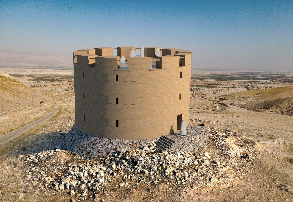
Although the tower at Poriya is in ruins, we know it would have originally had a diameter of 19 meters and consisted of three concentric circular walls. It was situated along an ancient road that runs north to south. Due to a lack of datable finds, the excavators were unable establish the timeframe of the ancient road.
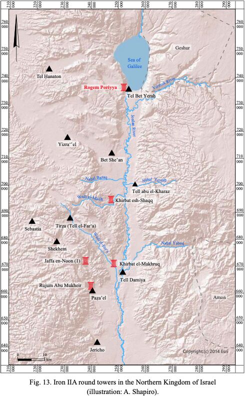
Including the tower at Rogem Poriya, a total of six round towers from Iron Age Israel are discussed in the paper, titled “Eyes to the East: Round Watchtowers Overlooking the Roads Leading From the Jordan Valley to the Kingdom of Israel in Iron Age II,” authored by Ron Be’eri, Avishay Oz, Аlexander Wiegmann, Yael Widerker Hilu and Tzachi Lang.
Based on the pottery, the towers were likely constructed in the Iron iia (10th-ninth century b.c.e.) and remained in use through the Iron iib (eighth century b.c.e.). The excavators suggest construction of the towers was initiated by King Omri or his son Ahab and continued to be used through the time of Jeroboam ii. The Bible describes the reigns of these kings as a time of prosperity and economic development.
Nineteen similar watchtower sites from the Iron Age have been discovered across the Jordan River in the territory of ancient Ammon. It is possible, as Be’eri et al suggest, that the Israelites influenced the Ammonites or vise versa.
The remains of three of the round watchtowers uncovered in Israel closely parallel the one found at Poriya in their form and size—Rujum Abu Mukheir, Khirbat el-Makhruq and Khirbat esh-Shaqq. Each tower has at least two concentric circular walls and measures 19 to 20 meters in diameter. While for the most part the foundations, constructed out of dry-built fieldstones, are all that remain, mud-brick remnants at the tower at Rujum Abu Mukheir lead the authors of the paper to suggest that the fieldstone foundation carried a mud-brick superstructure, containing windows and balustrades—a style known from other sources.
All of the towers were located away from urban centers and in a semi-arid area—not well suited for agriculture—indicating that their main purpose was safeguarding. Their position on elevated spurs throughout the landscape gave them a great vantage point to scour the surroundings and the trade routes below. Each of the towers faces east, toward the kingdom of Ammon; the Ammonites were one of the main enemies of the Israelites.
The similarity between the towers shows that they were “planned together” by a centralized administration in the northern kingdom of Israel that purposefully constructed them along this route, according to Be’eri et al. “It is clear that the establishment and maintenance of such a network of towers and fortresses alongside the main transportation arteries required centralized, state-level initiative and administration,” the paper says.
Watchtowers like the one at Poriya served different functions in peace and wartime. The positioning of the watchtowers away from the main settlements “enabled the provision of real-time intelligence and the transmission of information from the frontier to the urban and administrative centers during wartime.” As such, they could have been “used to detect trade caravans and military forces, provide information on their size, direction and speed, and report whether they were stationary or in motion.”
This leads the authors to believe that security in wartime was therefore the main purpose for their construction. They write: “The establishment of a network of towers along the eastern border of the northern kingdom of Israel in the ninth and eighth centuries b.c.e. reflects a clear set of priorities in which the fortification of frontier zones was regarded as a matter of paramount importance.”
Alongside security purposes they could also have served to collect and store taxes on agricultural products—similar to other fort-like structures in ancient Israel (called “storehouses” in the Bible). Due to their position along important roads, their function, and the dating of these towers, the excavators at Poriya believe that this network “made a substantial contribution to the stability and prosperity of the northern kingdom of Israel during this period.”
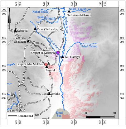
Although the distance between the excavated towers is too large, the authors of the report suggest the possibility that the towers along this network were in line of sight of each other and were able to communicate through fire signals—a practice recorded on one of the ostraca of the Lachish Letters. If this is the case, other towers would have had to have been interspersed along the Jordan Valley.
In 2 Kings 17:9, towers that served the purpose of guarding and watching a certain region are called “tower[s] of the watchmen”—migdale nozerim in Hebrew. Another term for watchtowers is mitspeh, used in 2 Chronicles 20:24 for the lookout positions “in the wilderness” from where the Judeans in the time of Jehoshaphat observed the infighting between the Moabites, Ammonites and Edomites across the Jordan River. Finally, 1 Chronicles 27:25 records that such watchtowers were already established in the days of King David, using the same Hebrew word migdal. There is no shortage of references to such towers in the Bible.
Lone standing watchtowers from the Iron Age have their parallel in the kingdom of Judah. The paper points to the towers of kings Uzziah and Jotham of Judah, biraniyot in Hebrew, that were distinct from the fortified cities and villages—indicating that they stood alone (e.g. 2 Chronicles 26:9-10; 27:4). Contrary to the Israelite towers along the Jordan River, however, Judean watchtowers were square.
For example, in the late 1970s Prof. Amihai Mazar excavated a square free-standing tower (11.5 by 11.5 meters) from the Iron Age ii at Giloh, constructed at the highest point in the site. Even though there were not enough finds to securely date the structure within the Iron ii timeframe, it was likely constructed during the eighth-seventh century b.c.e. In his report on the tower, “Iron Age i and ii Towers at Giloh and the Israelite Settlement,” Mazar suggested—similarly to the excavators of Rogem Poriya—that the Giloh tower could have been part of a network of towers that communicated through fire signals:
From the tower at Giloh, one can easily see an Iron Age fort at H. ‘Eres, west of Kibbutz Ma’aleh ha-hamishah, from which on can see the coastal plain and the Beth Horon ascent, where the main road leading to Jerusalem from the coastal plain passed. The Iron Age towers discovered at Tell el-Ful and on the French Hill and the palace-fort at Ramat Rahel are also visible from Giloh, thus establishing eye contact within a chain of strategic positions around Jerusalem. This location of the watchtower at Giloh explains its strategic importance, although it is about 2 kilometers west of the main road leading from Jerusalem to Hebron.
That the towers found in the northern kingdom of Israel were round sets them apart from those in Judah and demonstrates the difference in administration between the two kingdoms after their split. Although their shape is different, their possible function of securing and relaying information about the important roads of their kingdoms through a continuous network remained the same.
https://www.youtube.com/watch?v=IyW7Kgeq0vE&time_continue=110&source_ve_path=NzY3NTg&embeds_referring_euri=https%3A%2F%2Fwww.biblewalks.com%2F